 | 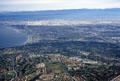 |  | 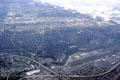 |
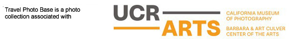
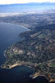
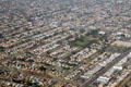
| Palos Verdes from air looking north. CA. | Palos Verdes & Redondo Beach from air looking north to LAX. CA. | Los Angeles International Airport from air on coast at right with boomerang shaped inlet of Marina Del Rey to left. CA. | Los Angeles International Airport from air from above intersection of San Diego & Santa Monica freeways. CA. |
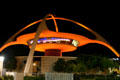 | 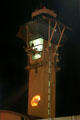 | 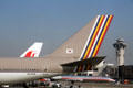 | 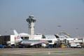 |
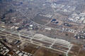
| Los Angeles International Airport Theme Building (1958). Los Angeles, CA. Architect: Pereira, Williams & Becket. | Los Angeles International Airport Control Tower (1993-5). Los Angeles, CA. Architect: Siegel Diamond. | Aircraft at Los Angeles International Airport. CA. | Los Angeles International Airport control tower & terminals. CA. |
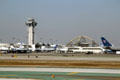 | 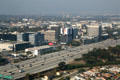 | 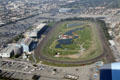 |  |
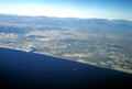
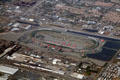
| Los Angeles International Airport control tower & terminals. CA. | Aerial view of San Diego Freeway near Los Angeles International Airport. CA. | Aerial view of Hollywood Park Racetrack in Inglewood, CA. | Aerial view of Inglewood residential areas. CA. |
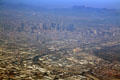 | 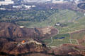 |  | 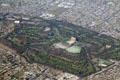 |
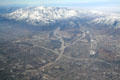
| Aerial view of downtown Los Angeles, CA. | Aerial view of Rose Hills Memorial Park in Whittier, CA. | Aerial view of San Gabriel Mountains above Baldwin Park, CA area. CA. | Aerial view of Industry Hills Golf Club in City of Industry, CA. |
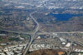 | 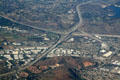 |  |  |
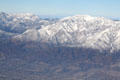
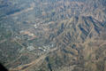
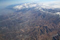
| Aerial view of Interchange of San Bernadino, Orange & Chino Valley Freeways beside Puddingstone Reservoir. CA. | Aerial view of Interchange of San Bernadino, Orange & Chino Valley Freeways. CA. | Aerial view of Mount Baldy in San Gabriel Mountains above San Antonio Heights, CA. | Aerial view of San Gabriel Mountains above Pomona, CA area. CA. |
 |  |  |  |
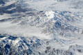
| Aerial view of Ontario International Airport. CA. | Aerial view of Mount Baldy in San Gabriel Mountains. CA. | Aerial view of California Speedway in Fontana, CA. | Aerial view along Barstow Freeway & Old Route 66 up mountains. CA. |
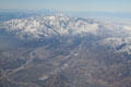 |  |  | 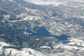 |
| Aerial view along Barstow Freeway & Old Route 66 up mountains. CA. | Aerial view of Highland, CA where freeway 330 meets 210. CA. | Aerial view of San Bernadino, CA along San Bernadino Mountains. CA. | Aerial view of Lake Arrowhead, CA. |
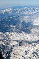 | 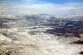 |  | 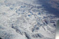 |
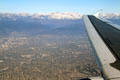
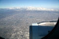
| Aerial view of San Bernardino Mountains with Lake Arrowhead, CA. | Aerial view of Apple Valley, CA. | Southwest US landscape view from air. CA. | Southwest US landscape view from air. CA. |
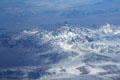 | 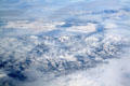 | 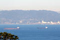 |  |
| Southwest US landscape view from air. CA. | Southwest US landscape view from air. CA. | Tankers on Santa Monica Bay. Los Angeles, CA. | Santa Monica & Marina Del Rey areas seen from Rancho Palos Verdes. Los Angeles, CA. |
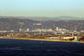 | 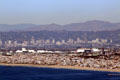 |  |  |
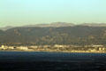
| Playa Del Rey area seen from Rancho Palos Verdes. Los Angeles, CA. | Manhattan Beach Pier, with Los Angeles International Airport, Wilshire Blvd. & San Gabriel Mountains beyond. Los Angeles, CA. | Hermosa Beach Pier & Redondo Beach Marina with Los Angeles International Airport beyond. Los Angeles, CA. | Century Blvd. highrises above Redondo Beach harbor Rancho Palos Verdes. Los Angeles, CA. |
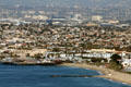 | 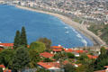 | 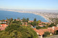 | 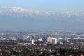 |
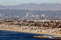
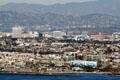
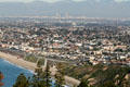
| View of area south of Los Angeles International Airport from Rancho Palos Verdes. Los Angeles, CA. | View of Rancho Palos Verdes & Redondo Beach. Los Angeles, CA. | Houses of Rancho Palos Verdes with Santa Monica in distance. Los Angeles, CA. | Skyline of Torrance & Mobil refinery area of Los Angeles against San Gabriel Mountains from Rancho Palos Verdes. Los Angeles, CA. |
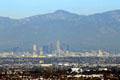 |  |  | 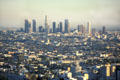 |
| Skyline of central Los Angeles against San Gabriel Mountains from Rancho Palos Verdes. Los Angeles, CA. | View of central Los Angeles over Redondo Beach from Rancho Palos Verdes. Rancho Palos Verdes, CA. | Skyline with 3 clusters of highrises: downtown LA, Century City & Westwood from Getty Museum garden. Los Angeles, CA. | Skyline of downtown from hills above Hollywood with round Capitol Records building in foreground. Los Angeles, CA. |