Blue Water Bridge & Huron Lightship, Port Huron, MI Photos

Port Huron, MI is a border town at northern end of St. Clair River between Lakes Huron & Erie. The most prominent feature is the Blue Water Bridge (1938) (1883m) between Port Huron, MI & Sarnia, ON which serves as a gateway to Canada. Near the bridge is the Huron Lightship (1921) Museum.

Click thumbnail to enlarge. F11 to view website full screen.
Huron Lightship now a museum in Port Huron. Port Huron, MI.Mast of Huron Lightship Museum against Blue Water Bridge. Port Huron, MI.Blue Water Bridge between Port Huron, MI & Sarnia, ON over St. Clair River. Port Huron, MI.Blue Water Bridge cantilever center span. Port Huron, MI.
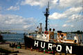
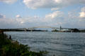
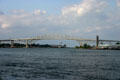
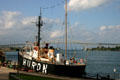
Huron Lightship (1921) now a museum in Port Huron. Port Huron, MI.Mast of Huron Lightship Museum against Blue Water Bridge. Port Huron, MI.Blue Water Bridge (1938) between Port Huron, MI & Sarnia, ON over St. Clair River (1883m). Port Huron, MI.Blue Water Bridge cantilever center span. Port Huron, MI.
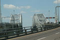
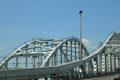
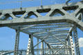
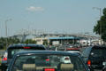
New & old spans of Blue Water Bridge. Port Huron, MI.Center span structures of Blue Water Bridge. Port Huron, MI.Ironwork details of Blue Water Bridge. Port Huron, MI.Traffic approaching Blue Water Bridge. Port Huron, MI.
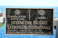
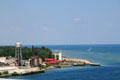
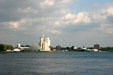
U.S. - Canada Boundary marker on Blue Water Bridge. Port Huron, MI.View from Blue Water Bridge to lighthouse of Port Huron, MI.Dockyards of Sarnia, ON seen from Port Huron, MI. ON.Clouds over Port Huron, MI. ON.

See Also:

All photos on this page are originals by & copyrighted by Jim Steinhart.
All rights reserved. Permission required to use.

CMP